“an icon of Auckland city”
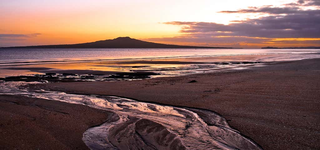
The youngest of the islands in the Hauraki Gulf, Rangitoto emerged from the sea around 700 years ago in a series of volcanic explosions. Rising to a height of 260 metres the circular island presents the same uniform appearance and is visible from most parts of the mainland. Rangitoto's name has been translated to mean the day the blood of Tamatekapua was shed, relating to a major Maori battle at Islington Bay about 1350. Rangitoto is an icon of Auckland city. Situated about 8 km northeast of Auckland and connected to Motutapu Island by a causeway, Rangitoto is a large island of 2311 hectares with a wonderful volcanic landscape that supports over 200 species of moss, plants and trees including the largest Pohutukawa forest in the world. It was purchased by the Crown in 1854, set aside as a recreation reserve in 1890 and for over 30 years the island's volcanic scoria was quarried and shipped to Auckland. Between 1925 and 1936 prison labour built roads on the island and a track to the summit. There are some 10 or so short and long walks around the island and from the summit there are magnificent views of the Hauraki Gulf, the Waitemata Harbour and Auckland city.
Reviews
Be the first to add a review to the Rangitoto Island Scenic Reserve.
/174.857685,-36.784649,14/300x172@2x?access_token=pk.eyJ1Ijoicm9hZHRyaXBwZXJzIiwiYSI6ImNsdjQ5N2VtZDA2bW8ycW13ZHAxeGhjbjkifQ.UIccpoAxc7g3BAuK4s9vjg)
Rangitoto Island Scenic Reserve
Hours
- Sun - Sat: 12:00 am - 11:59 pm
Problem with this listing? Let us know.
Has RV parking changed? Let us know.
-
Parking
-
Pets Allowed
-
Restrooms
-
Wifi
-
Wheelchair Accessible
-
Credit Cards Accepted
Nearby Hotels
Related Trip Guides
- Trip Guide
Wellington to Gisborne Long Weekend Roadie
- 18 Places
- 19:22
- 826 mi
- Trip Guide
Cycle The Otago Central Rail Trail
- 34 Places
- 04:20
- 169 mi
- Trip Guide
Great Alpine Highway
- 29 Places
- 10:42
- 414 mi
- Trip Guide
New Plymouth to Gisborne Long Weekend Roadie
- 12 Places
- 14:06
- 621 mi